Tanzania gold mine, Geita District, Tanzania, 2024
Introduction
In 2023-2024, an exploration survey was conducted at the Ore Gold Licence in northeastern Tanzania, a site spanning over 10 million square meters. The survey aimed to uncover promising gold deposits using an innovative geophysical method known as Geological Exploration Microseismic Sounding (GEMS). This case study explores how GEMS technology was successfully applied to increase the precision of gold prospecting in a challenging geological environment.
Challenge
Traditional gold exploration methods often require extensive and costly drilling to locate ore deposits, which is not only resource-intensive but also environmentally invasive. The challenge at the Ore Gold Licence site was to reduce these costs and minimize environmental impact while still conducting an effective exploration of a vast, uncharted area.
Preliminary findings suggested that past magmatic activity might have created geological conditions favorable for gold deposition. However, accurately identifying specific zones of interest required a more advanced method that could visualize subsurface structures without extensive drilling.
Solution: GEMS Technology
To address this challenge, the exploration team implemented the GEMS (Geological Exploration Microseismic Sounding) method. GEMS is a passive seismic prospecting technique that uses the natural microseismic activity of the Earth to detect areas of varying seismic wave velocities.
This method is particularly well-suited for identifying zones of increased fluid conductivity, micro-cracking, and quartz enrichment—key indicators of potential gold ore deposits. GEMS works by analyzing how microseismic waves travel through the subsurface and identifying areas where the waves slow down, which may indicate fractures or occlusions associated with gold deposits.
Methodology
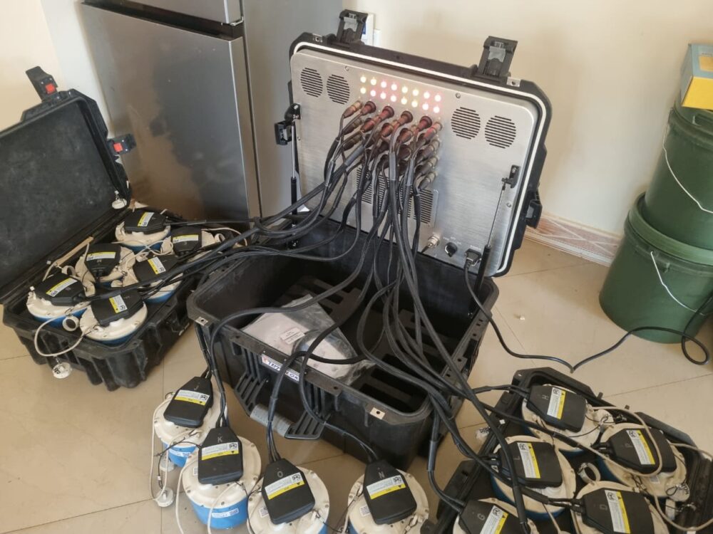
1. Survey Scope: The survey covered the entire 10,097,000 square meters of the Ore Gold Licence. A total of 1,690 data points were measured, with each point recording microseismic signals for at least six hours.
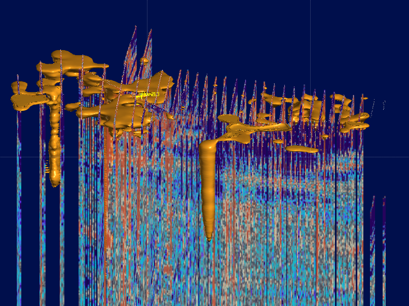
2. Data Collection: The microseismic signals were processed to create a 3D model of the subsurface, revealing the spatial distribution of seismic wave velocities down to a depth of 4.5 kilometers.
3. Data Interpretation: The results were visualized in the form of a layered depth distribution model, highlighting zones of reduced seismic wave velocities. These areas were interpreted as zones of increased fracturing and fluid movement, which are highly correlated with gold-bearing structures.
Key Findings
– Identification of Vertical Structures: The GEMS data revealed several vertical structures resembling magmatic roots, with wider zones near the surface. These structures are consistent with secondary magmatism, where fluid escapes toward the surface, potentially carrying gold deposits.
– Narrowed Exploration Focus: The 3D model allowed the team to pinpoint specific zones of interest for further exploration, significantly narrowing down the areas that require costly drilling. This improved both the accuracy and cost-effectiveness of the exploration efforts.
– Promising Zones for Drilling: The areas identified through GEMS are now prime candidates for targeted drilling, significantly reducing the amount of trial-and-error usually involved in gold exploration.
Outcome and Impact
By applying GEMS technology, the exploration team at the Ore Gold Licence site achieved several key outcomes:
– Cost Reduction: The ability to focus drilling efforts on promising areas has the potential to save millions of dollars in exploration costs.
– Environmental Sustainability: The passive nature of the GEMS method reduced the need for invasive drilling, minimizing the environmental footprint of the exploration project.
– Enhanced Accuracy: The detailed 3D model provided valuable insights into the subsurface, allowing for more informed decision-making and reducing the risk of unproductive drilling.
Conclusion
The application of GEMS technology at the Ore Gold Licence in Tanzania has proven to be a game-changer in gold exploration. By leveraging advanced geophysical methods, the exploration team was able to identify high-potential zones more accurately, reduce costs, and minimize environmental impact. This case study demonstrates how innovative technologies like GEMS can transform the way we approach resource exploration, making it more efficient, cost-effective, and sustainable.
As the next phase of exploration begins, which involves targeted drilling in the identified zones, the full potential of the Ore Gold Licence is yet to be realized. However, the success of the GEMS survey has already set a new standard for gold exploration in challenging environments.
Terravox Partners with Rota Mining Ltd for Gold Deposit Survey in Geita Region
Terravox is pleased to announce its collaboration with Rota Mining Ltd, a prominent local mining company, to conduct a comprehensive survey of a significant gold deposit in the Geita region. This partnership leverages Terravox’s advanced GEMS technology, which has proven to deliver 100% accuracy in identifying gold deposits and precisely determining ore body size and dimensions.
The Geita region, known for its rich mineral resources, represents a key area of interest for both Terravox and Rota Mining Ltd. Using our state-of-the-art GEMS technology, we have conducted an extensive survey that has yielded highly accurate data on the location and dimensions of the gold deposit. This data has been instrumental in developing a detailed 3D model of the ore body, providing a clear visualization of the deposit’s structure and potential yield.
The accuracy of our 3D model was subsequently validated by the results of targeted drilling operations, which confirmed our survey’s findings and demonstrated the precision and reliability of GEMS technology in real-world applications. This breakthrough underscores Terravox’s commitment to utilizing cutting-edge technology to enhance exploration and mining efforts, reducing uncertainty and improving operational efficiency for our clients.
Our partnership with Rota Mining Ltd marks a significant step in our efforts to support the local mining industry with innovative solutions that maximize resource identification and extraction. By combining our technological expertise with Rota Mining Ltd’s local knowledge and experience, we are paving the way for more efficient and sustainable mining operations in the Geita region.
Terravox is proud to contribute to the growth and success of mining activities in the Geita region and looks forward to continuing our collaboration with Rota Mining Ltd. Together, we are setting new standards for exploration and mining excellence, leveraging technology to unlock the full potential of mineral resources.
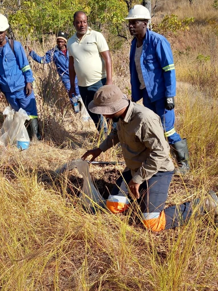
Refunsa gold area, Zambia, 2023
In a groundbreaking endeavor, the power of Microseismic Sounding Technology took center stage as it partnered with Zambia Gold Ltd to explore the historic Refunsa fault, a geological feature of immense significance.
The primary objective of this venture was to showcase the immense capabilities of Microseismic Sounding Technology to Zambia Gold Ltd, focusing on the Refunsa fault, an ancient fault line with a rich geological history. This collaboration aimed to highlight the cutting-edge approach MST brings to the table in unraveling the Earth’s secrets.
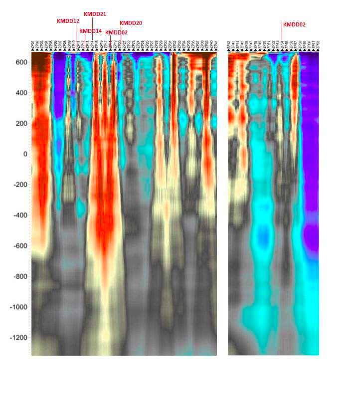
To gauge the effectiveness of Microseismic Sounding Technology, Zambia Gold Ltd meticulously compared their findings with the comprehensive report prepared by Terravox, a pioneer in this innovative field. Even with the limited data available from Zambia Gold, the results from the MST surveys were striking. These surveys revealed specific areas that hold immense promise and warrant further investigation, either through exploratory drilling or by obtaining closer station spacing profiles. This detailed information promises to optimize the selection of drill sites for future exploration endeavors.
One of the most astonishing revelations emerged during Terravox’s two-week blind test, where the Microseismic Sounding Technology delivered an astounding volume of data that eclipsed the cumulative output from over two years of previous geophysical studies and drilling. This revelation speaks volumes about the sheer efficiency and precision that MST brings to the exploration landscape.
The collaboration between Terravox Global Ltd and Zambia Gold Ltd stands as a testament to the transformative potential of cutting-edge geophysical methodologies. This achievement opens the door to more informed decision-making in resource exploration, ushering in a new era of efficiency, accuracy, and insight. As the industry evolves, stories like this underscore the invaluable role that technology plays in redefining how we understand and harness our planet’s geological wealth.
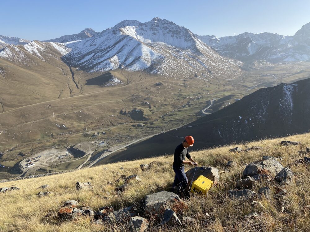
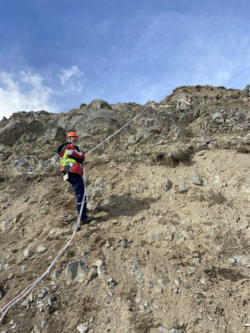
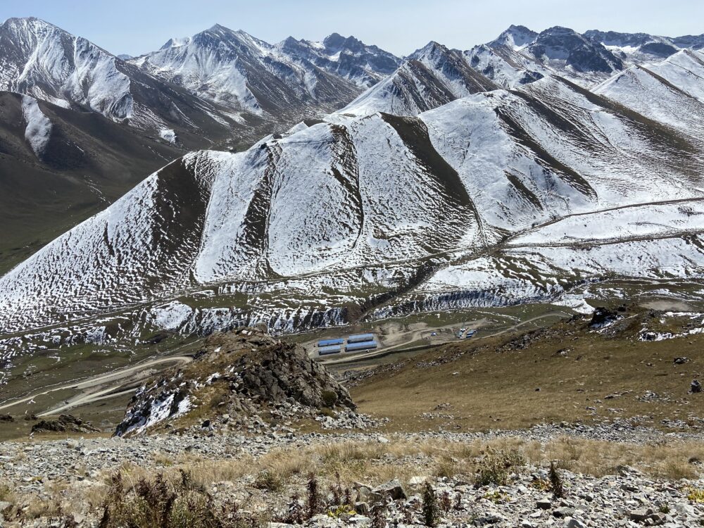
Jerui Gold Deposit, Kyrgyz Republic, 2020
The project took place in the highlands, at elevations ranging from 3050 to 3300 meters, amidst rocky and rugged terrain.
The primary goal of the project was to minimize the need for extensive exploration drilling.
After analyzing the interpretation data, mine operator proceeded with exploratory drilling, which led to the identification of a significant fault zone with substantial thickness.