Gold exploration is entering a new era with cutting-edge geophysical techniques enhancing our ability to locate hidden resources. In the northeastern part of Tanzania, a recent project at the Ore Gold Licence demonstrates how advanced methods like GEMS (Geological Exploration Microseismic Sounding) are transforming the search for gold in challenging terrains.
Unlocking Gold Reserves at the Ore Gold Licence
Located near Ruamagaza, Tanzania, the Ore Gold Licence spans a vast 10 million square meters, making it a prime site for exploration. With the growing demand for cost-efficient exploration methods, GEMS was selected for its ability to detect potential gold deposits deep beneath the Earth’s surface, without the need for invasive drilling during the initial phases.
Preliminary assessments of the area suggested that the region’s geological history might hold promising gold deposits, stemming from past magmatic activity. The goal of the project was to identify subsurface fractures and fluid channels that often serve as key indicators of gold ore deposits.
Harnessing Advanced Technology for Gold Exploration
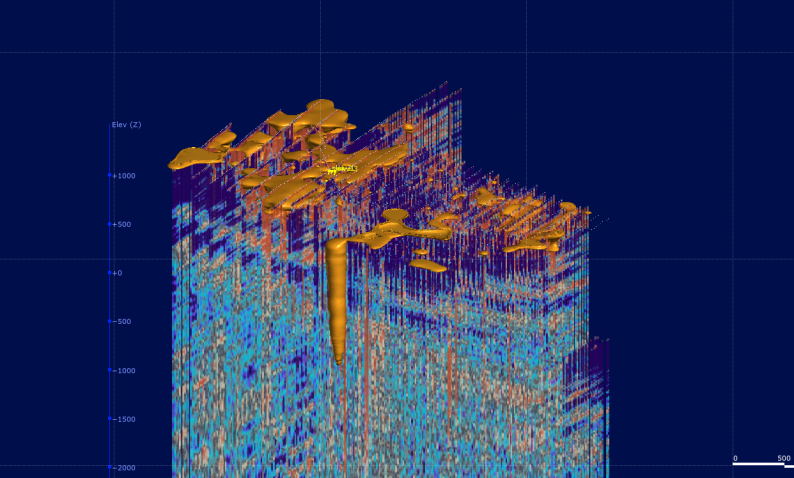
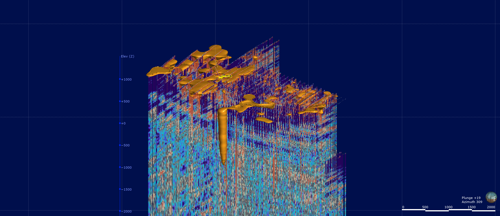
The GEMS method, known for its ability to detect subtle variations in seismic wave velocities, was applied to map the underlying geology of the Ore Gold Licence. A total of 1,690 survey points were distributed across the licence area, each recording microseismic signals for six hours. These data points helped construct a detailed 3D model of the subsurface, reaching depths of 4.5 km.
“Our focus was on identifying zones of increased fracturing and reduced seismic wave velocities, which are often associated with ore-bearing formations,” says the lead geophysicist on the project. “The GEMS method allowed us to visualize the underground structure and pinpoint areas that warrant further exploration.”
Promising Results and Interpretations
The survey delivered significant results, highlighting zones of reduced seismic wave velocities that are consistent with the presence of fractured rock and quartz enrichment—both promising indicators of gold deposits. The 3D model revealed vertical structures resembling magmatic roots, with wide zones near the surface, hinting at potential gold concentrations within these formations.
“The GEMS technology enabled us to narrow down the exploration area, allowing for more targeted drilling,” explains the project leader. “This drastically improves cost-efficiency, as we can now focus our efforts on the most promising locations.”
Challenges and Future Directions
While the initial findings are promising, the interpretation of the data presents some challenges. The presence of multiple vertical structures, while indicative of potential ore deposits, requires further investigation to confirm the extent and concentration of the gold within these zones.
The next phase of exploration will involve drilling in the identified areas to verify the presence of gold. This phase will not only provide more concrete results but will also help refine the GEMS technology for future applications in gold exploration.
The Future of Gold Exploration with GEMS
The success of the GEMS method at the Ore Gold Licence marks a pivotal moment for gold exploration. By providing a clear, detailed understanding of the subsurface, GEMS significantly reduces the time and resources needed for initial prospecting efforts.
As this technology continues to evolve, it has the potential to revolutionize exploration not just in Tanzania, but in gold-rich regions worldwide. Projects like the Ore Gold Licence demonstrate that innovative geophysical methods can pave the way for more efficient, cost-effective, and sustainable gold mining.